
Kaiqiang Zhang, School of Law, Tsinghua University, People’s Republic of China
Background
On Tuesday 12 October, the International Court of Justice (the Court) delivered its judgment on the merits of the maritime delimitation in the Indian ocean between Somalia and Kenya. For the first time, the Court had a chance of dividing the extended continental shelf between two (adjacent) States beyond their 200 NM limit (extended continental shelf).
According to Art. 76 of the United Nation Convention on the Law of the Sea (‘UNCLOS’), a coastal State is entitled to a continental shelf which is ‘the natural prolongation of its land territory’ up to a distance of 200 nautical miles (NM) from its baselines. However, if the continental margin extends beyond 200 NM, the outer limit should be determined by geological and geomorphological criteria specified in Art. 76 UNCLOS. Importantly, the outer limit beyond 200NM shall be determined by a coastal State on the basis of recommendations provided by the Commission on the Limits of the Continental Shelf (CLCS), an expert body established by Annex II of the UNCLOS comprising 21 members in the field of geology, geophysics or hydrography (Art. 76.8).
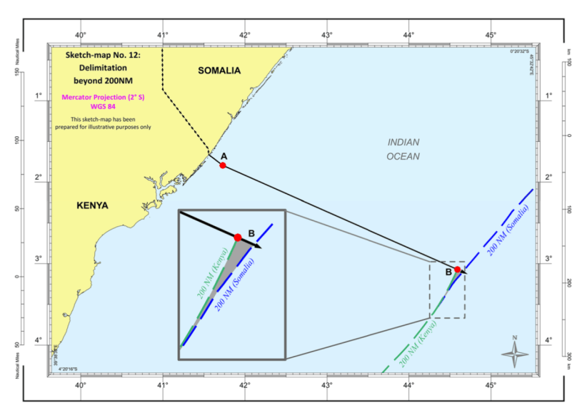
By nine votes to five, the Court held that the outer maritime boundary ‘continues along the same geodetic line until it reaches the outer limits of the continental shelf or the area where the rights of third States may be affected’ (at [214]). By contrast with the approach of the Court in its case law concerning the continental shelf delimitation within 200 NM, the extended continental shelf boundary was determined in a general fashion without precise coordinates or even an endpoint, no recommendation having yet been issued by the CLCS (at [188]). This blog post argues that, in the absence of CLCS recommendation, the Court should decline to delimit the extended continental shelf, or at least should have done in this case. Indeed, the approach adopted by the Court in Somalia v Kenya raises several problems and may lead it astray in the future, especially as 2016 Nicaragua v. Colombia is waiting on the docket.
Rethinking the Jurisdiction Obstacle
Since the International Tribunal for the Law of the Sea (ITLOS) took the lead in the case of Bangladesh v. Myanmar (2012 ITLOS Judgment [384-394]), it now seems undisputed that the CLCS’s recommendation concerning delineation does not preclude international courts and tribunals from establishing the jurisdiction and admissibility concerning delimitation (under Art. 83 of the UNCLOS). As repeatedly confirmed by the Court, ‘the lack of delineation of the outer limit of the continental shelf is not, in and of itself, an impediment to its delimitation between two States with adjacent coasts’ (at [189]). However, two observations still need to be stressed.
First, the present case is unique since Somalia and Kenya concluded a Memorandum of Understanding (MOU) in 2009 in which they arranged a time-line of dispute settlement. Para. 6 of the MOU provides:
‘The delimitation of maritime boundaries in the areas under dispute, including the delimitation of the continental shelf beyond 200 nautical miles, shall be agreed between the two coastal States on the basis of international law after the Commission has concluded its examination of the separate submissions made by each of the two coastal States and made its recommendations…’[emphasis added].
However, by way of contextual and teleological interpretation, the Court in its 2017 Judgment held that the MOU did not create additional dispute settlement methods, and that Para.6 cannot be interpreted as “precluding the Parties … from resorting to dispute settlement procedures regarding their maritime boundary dispute, before receipt of the CLCS’s recommendations” (2017 ICJ Judgment, at [95]).
Four out of five dissenting and separate opinions disagreed with the Court’s interpretation concerning Para. 6 of the MOU. As argued by Judge Bennouna, the Court cannot disregard the order of treaty interpretation methods embedded in Art. 31 of the Vienna Convention on the Law of Treaties (VCLT) and jump to the MOU’s “object and purpose” without first examining the ordinary meaning of the text, which “clearly and unambiguously” gives “priority to the work of the CLCS.”(at [p.62]). Other dissenting judges support similar arguments. Judges Gaja and Crawford propose that the use of the word “after” sets a time limit for negotiations and the word ‘shall’ connotes an obligation to respect that time limit (p [64-65]). Thus, neither party was free to take unilateral action to resort to courts and tribunals “before the CLCS had made recommendations” (p [64]). The ad hoc Judge Guillaume upheld that delineation is not a step to in the process of delimitation, but retorted that what both parties concluded in the MOU suggested that they had chosen delimitation taking place after delineation (p [82]). The rationales given in dissenting opinions are persuasive as the Court appears prepared to disregard an explicit bilateral agreement in its eagerness to establish jurisdiction.
The second observation is not limited to the present case. It should be noted that the courts and tribunals (those under Part XV of the UNCLOS) vary regarding the stage of the proceedings at which the absence of CLCS recommendations should be addressed. In practice, the lack of CLCS recommendations has been discussed when determining jurisdiction (Saint-Piere and Miquelon; Ghana/Côte d’Ivoire; 2012 Nicaragua v. Colombia), the exercise of jurisdiction (Bangladesh v. Myanmar; Bangladesh v. India), admissibility (2016 Nicaragua v. Colombia; Ghana/Côte d’Ivoire) and even during the discussion of the merits (mainly concerning the establishment of entitlements, Ghana/Côte d’Ivoire; Nicaragua v. Honduras). In 2012 Nicaragua v. Colombia, the Court created an additional part, neither belonging to the admissibility nor the merits, to address this issue. In the present case, throughout the jurisdiction (2017 ICJ Judgment [90-97]), admissibility (at [137-142]) and merits (at [189]) stages, the Court highlighted that the absence of the outputs of the CLCS does not preclude the delimitation task of the Court. This inconsistent and fragmented approach does not have a legal basis in procedural law and may not set an example for dispute settlement in the future.
The (Lack of) Evidentiary Basis for An Extended Geodetic Line
As regards the case law on delimitation, the Court found in the case at issue that “an essential step in any delimitation is to determine whether there are entitlements and whether they overlap” (at [193]). With regard to the entitlement of a State to the continental shelf beyond 200 nautical miles, the Court argued that it depends on geological and geomorphological criteria (Para. 193), not the distance criterion which supersedes the former in defining a coastal State’s entitlement to a continental shelf up to 200 nautical miles. Thus, the Court endeavoured to determine the entitlements by reference to the outer edge of the continental margin, according to Paras. 4 and 5 of Art. 76 of the UNCLOS. The Court also referred to the Bangladesh v. Myanmar case invoked by Somalia, but distinguished it on the basis of the unique geological situation in the Bay of Bengal, involving a ‘thick layer of sedimentary rocks’ which was held to be “sufficient to enable the Tribunal to proceed with the delimitation of the area beyond 200 nautical miles’(at [190-193]).
Though the Court is aware of the requirement that reliable information confirming the existence of a continental margin in the area beyond 200 nautical miles should be available, nowhere in the Judgment did it refer to this scientific evidence. Neither did it show that the geological and geomorphological criteria for the existence of a continental shelf beyond 200 nautical miles were met in this case. In Bangladesh v. Myanmar, the ITLOS found that ‘it would have been hesitant to proceed with the delimitation of the area beyond 200 NM had it concluded that there was significant uncertainty as to the existence of a continental margin in the area in question’ (2012 ITLOS Judgment, at [443]). However, in this case, the Court still established the existence of the entitlements based on the claims of the Parties in their submissions to the CLCS and the fact that ‘neither Party questions the existence of the other Party’s entitlement’(at [194]). According to Judge Robinson, the Court has overvalued the volition of the Parties and the lack of any scientific data to substantiate the existence of a continental shelf undermines the validity of the Judgment. Along the same line, President Donoghue emphasised that ‘it cannot be assumed that the Commission will adopt any State’s submission’ so that the evidence regarding the “existence, extent, shape or continuity of any outer continental shelf” is still lacking (at [8]).
Furthermore, since several judges disagreed with the way the Court adjusted the provisional medial line within 200 NM (Judge Robinson, Judge Yusuf, Judge Xue and Judge Abraham), they questioned whether a maritime boundary extending from an inequitable line could entail any equitable solution beyond 200 NM, as required by Art. 83 of the UNCLOS. The possible “gray area” as an outcome of the Court’s delimitation also attracted the attention of the judges. As argued by Judge Yusuf, this ‘may also lead in the future to a “Court-created” new problem between the Parties’ (at [6]), such as encroaching on the sea-bed area (at [17-20]).
Concluding Remarks
This post considers the relations between the process of delineation and delimitation of the extended continental shelf. At least in the current case, the lack of recommendations from the CLCS not only undermined the basis of the Court’s jurisdiction, but also made the Court’s reasoning appear unconvincing, if not flawed or invalid. Thus, it cannot be taken for granted that ‘the lack of delineation of the outer limit of the continental shelf is not, in and of itself, an impediment to its delimitation between two States with adjacent coasts’(at [189]).
It is worth noticing that until now, all the decided cases concerning the delimitation of extended continental shelf involved States with adjacent coasts (Bangladesh v. Myanmar; Bangladesh v. India, Ghana/Côte d’Ivoire and the present case). The delimitation between States with opposite coasts, as is the case in the forthcoming Nicaragua v. Colombia, is quite different and much more complicated. First, the overlapping area necessary for delimitation is depicted by the outer limits of the extended continental shelf of each state, which could only be determined by the CLCS in advance. Second, the Court now encounters a scenario where Nicaragua’s claimed natural prolongation of the shelf extends into the Exclusive Economic Zone (EEZ) of Colombia. No conventional law, customary rules or case law provide guidance on this issue. The Court avoided responding to those arguments in 2012 (2012 ICJ Judgment, at [129]), but since it re-opened the case in 2016, it will inevitably face the tough nut in the future.
All things considered, the delimitation of the extended continental shelf between Somalia and Kenya, as the ICJ’s debut, may not provide appropriate guidance for the Court’s future work. Worse, the Court may have opened the Pandora’s box when it decided to delimit the extended continental shelf (between Somalia and Kenya) before the CLCS gave its recommendations.
